The Village of St. Rapnel
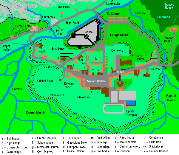
Location
St. Rapnel is a small town, or large village, about a third of the way up the Rapnel Valley, a secluded cul-de-sac with sheep farms at its upper part, with a great marsh filling up most of the southern part below the river. (A 1940s proposal to turn this into a reservoir by damming up the river at Scrape Farm and turning the town embankment into a huge levee was never eventuated, thank God.) To north and south of the valley are high fells and moorland, mainly given over to raising sheep. There are dolmens and burial mounds on the northern fells, as well as an embanked hill fort, showing occupation from Neolithic times, but no sign of a stone circle or village, unless one considers the unexcavated knoll and castle site as being the location of these people, who seem to have been rather primitive and shy of outsiders. No doubt many of the locals are descended from these folk, as nothing much has ever happened here apart from some harrowing by the Normans and a bit of bother in the Civil War.
St. Rapnel is located in the northern Peak District southeast of Sheffield, near Hathersage and north of the famous plague village of Eyam. It is basically a hidden vale through which runs the Rapnel River, a tributary of the Derwent. The valley is not much more than three and a half miles in length, and is hidden amidst high fells. The nearest town of any size is Laxminster, a suburban outlay of Sheffield. Between Laxminster and St. Rapnel is the forest of Fairwood, an old Norman deer hunting preserve.
The main part of the town is located south and east of the Castle, below the large village green. The population, in 2002, was estimated at some 800 people, if one includes the outlying houses and farms.
History
The Rapnel Valley, then called Hrofswold, was referred to by the Venerable Bede in Anglo-Saxon times as a refuge against the Vikings, and it was an early Christian site. Who Saint Rapnel was is lost to history, but it is assumed he was an early missionary of the Britons of Iona and Lindisfarne. By the time of the Domesday Book, the valley was rather heavily populated; this soon declined drastically, as the area was subject to the notorious 'harrowing of the north' following the Conquest. It was given over to Ralph de Courtenay, an illegitimate son of Duke Robert of Normandy, and made into a hunting forest for deer and a private preserve, which it remained until the 14th Century when raising sheep became more important. It prospered to the extent that the main part of the Parish Church and its tower were constructed. De Courtenay's original wooden stockade was embanked and provided with a keep and stone curtain walls, to become the now ruinous castle. At the same time, an earthen embankment was built along high ground alongside the great marsh to enclose a small town (originally sited along the river bank on a small gravelly ridge with the Knoll to the west and the castle to the east).
St. Rapnel made its way through the Middle Ages without much ado, being bypassed by the various ducal wars and upheavals and even being spared from the Black Death plague. At the time of the Civil War, however, the Barons de Courtenay chose to support the losing side (Charles I) and suffered consequently the loss of status and position. Their castle was 'slighted' by Cromwell's troops and the family had to flee to France for the duration of the Commonwealth. (The castle had been rendered indefensible prior to this when Sir Charles de Courtenay dismantled most of the buildings in the outer ward to build his almshouse and the de Courtenay chapel in the parish church.) After the Restoration, the male line died out, the estate passing down to the eldest daughter, who married a local army Colonel, one Benjamin Compton. A century later the Ginnetts from Sheffield, famous sword manufacturers, married into the family, which has been hyphenated ever since.
Interesting Sites
- (a) The Toll House In the late 18th Century, the road up the valley was widened and a toll imposed by the Compton-Ginnetts; this was soon discontinued, as travellers simply skirted the toll booth. It is now a bus stop. There is a small caravan/campground site along the river bank a few hundred yards up the valley.
- (b) Scrape Farm and the High Bridge This farm is the largest in the upper valley and originally dates back to Medieval times. The same family has inhabited it for some 600 years. High Bridge leads to the Knoll, a small 'suburb', and to the northwest road into the village.
- (c) The Scrape Arms Public House This is the local 'hang-out' for the farmers and sheepherders of the upper Rapnel Valley. It is not generally a place where tourists feel welcome.
- (d) Gum Bridge Carries the High Road over the Gum Brook, which runs down from the northern fells. There is a car park adjacent from which hikers can visit the fells. A picnic park on the St. Rapnel river bank has nice views of the castle. In the summer, hot dogs, ices, and sodas are sold out of a lorry ('Vinnie's Vittles') that frequents the area.
- (e) The Green Lion Public House The 'posh' pub, dating from the 18th Century. Five nearby houses are owned by schoolteachers and lawyers. To its west are the shops of High Street.
- (f) School and Sports Complex This large building dates from the 1930s and is now the St. Rapnel Regional Comprehensive School. In the meadows south of it is a sports center also built at that time, consisting of a gymnasium, football field, running track, tennis courts, and a swimming pool.
- (g) Methodist Church Built in 1823 in Greek Revival Style. At least a third of the townspeople are Methodists, dating from the evangelism of the preacher Rev. Amos Gowcher in the Regency Period. The minister lives in the house by the Fair Bridge, a nicely appointed late Georgian building.
- (h) Corn Market 1872. The indoor market for the town/village. Full of small stalls selling everything from cheap imported junk clothes to antiques.
- (i) St. Dismas RC Church There are perhaps three dozen Roman Catholics in St. Rapnel, mostly descended from Italian prisoners of war who were interned in Laxminster during World War II. The building was originally the Chapel of the Alms House, and dates to the early 17th Century. Fr. Giacomo Spinelli soldiers on as the current priest, even though he is in his eighties and very feeble.
- (j) Gascoigne Hotel This Edwardian building is the finest (and only) hotel in the village. Its restaurant serves traditional local cuisine such as roast lamb and Yorkshire pudding, and the smoking-room and bar are where the 'businessmen' do many of their deals.
- (k) Grimpon Close A small cobbled side street with two-up-two-down workmen's houses on each side; there are more of the same along the road to the cemetery (Dagger Lane). Very twee now.
- (l) Police Station 1937. A rather grim dark limestone building, which also contains a small prison (mainly now used for drunks and petty thieves). Superintendent Alan Bracegirdle is the current head of this station.
- (m) Post Office As in many villages, this is the gossip center, right out of Agatha Christie.
- (n) Vicarage and High Street Bernard Axelrod Humbleside is the rector of the 14th-century Parish Church of St. Rapnel. See the Parish web page on the latter building. The vicarage itself is an impressive small four-storey house from the Victorian era. It is on the corner of High Street and Lych Street, which leads to the cemetery. High Street, the main shopping street, runs eastwards from the Market Square; paradoxically, High Street becomes the Low Road. Among the shops is a book store, a 'bodega' run by Senor Velasquez, an immigrant from Honduras, two shoe stores (one constantly advertising that it is going out of business), a pins and needles shop, and a haberdasher.
- (o) Low Bridge and the High Road The principal entry to the village, leading to the village green, with the postern gatehouse of the castle on your right as you go southeast. Traffic must bear southwest from the junction in front of the main gatehouse of the Castle, as Dagger Lane is blocked by ballards (1982). It is an attractive stone-arched bridge. The high road leads to the upper valley to the west and east to Laxminster, the largest nearby town, located at the bottom of the valley, near where it runs into the River Derwent. Some quarter of a mile northeast of the area shown on the map is Gruntley House, site of a famous murder case.
- (p) Fair Bridge and Fairwood Manor Fairwood Manor is just over this bridge to the dark and winding lane called the Low Road through Fairwood Forest, a five-square-mile beechwood and oak woodland that is a deer sanctuary, that leads eventually to Laxminster. For more on the manor, go to this web page.
- (q) Alms House (Museum and Public Library) Sir Charles de Courtenay built this home for indigent elderly servants and agricultural workers during the reign of Charles I. It is now the town museum and library. A small hospital, built in the 1950s, is just southwest of this building.
- (r) The Odeum [sic] Movie Theatre An Art-Moderne structure dating from the 1920s that still operates as a movie 'palace', although occasionally amateur stage productions are staged here. It is managed by Mrs Mabel Smytherton, a well-known local harridan. Her quarrels with the drunken projectionist Sam Samson provide a prime amusement for the locals.
- (s) Bird Observatory 1956. A small wooden structure atop the Embankment, with windows to observe the abundant bird life in the St. Rapnel Marshes. Owned by the Laxminster Bird-Watching Society. Open to the public (no charge).
- (t) Tea Pavilion 1904. An octagonal rotunda overlooking the bowling green and the cricket pitch; serves tea and scones, now also snacks, during clement afternoons in summer and on weekends. Miss Sally Knolls, an avid church-goer and chairlady of the Flower Guild, is its proprietor. She also has an indoor teahouse opposite the police station -- very popular with the local women.
- (u) Magistrate's Court 1902. A glum limestone building constructed when the village was of more importance. It is now a small-claims court and place for trying minor crimes such as poaching and drunkenness. The chief magistrate is not, as one would expect, the squire of Fairwood Manor, but Mr Titus Tittle, ex-MP.
- (v) Guild Hall Apart from the parish church and the castle, this is the oldest building in the village, although it has been remodelled several times. Raised on brick stilts, it is an architectural landmark and dates back to the time of King Edward VI.
- (w) Snickelway A foot passage leading up from the Market Square (via an archway between the Gascoigne Hotel and a clothing shop, the Bros. Marks) past some small cottages and row houses to the Alms House.
Home Page